

Namibia rewards travellers who slow down. Distances are large, many scenic roads are gravel, and the best moments often happen between headline stops: an empty horizon, a roadside weaver-bird nest or the first wildlife gathering at an Etosha waterhole. This ten-day Windhoek loop balances desert, Atlantic coast and safari time without turning every day into an endurance drive.
Trip at a glance
- Theme: Desert landscapes, wildlife and remote-road adventure
- Recommended length: 10 days / 9 nights
- Start and finish: Windhoek
- Approximate distance: 2,000–2,400 km, depending on lodge and gate choices
- Best season: May to October for cooler, drier driving; July to October is high demand
- Driving difficulty: Moderate to challenging because of gravel, long gaps and wildlife
- Indicative budget: US$1,800–3,200 per person when two travellers share a suitable vehicle and rooms; camping can reduce the total
Route and LBS waypoints
Save this sequence before leaving Windhoek: Windhoek → Sesriem → Sossusvlei → Solitaire → Swakopmund → Cape Cross or Spitzkoppe → Damaraland → Etosha South → Etosha East → Okonjima area → Windhoek. Download offline maps, but also carry a paper map. Mobile coverage disappears on remote sections.
Day-by-day route
Day 1 — Windhoek arrival and preparation
Do not schedule a long gravel transfer after an overnight flight. Collect the vehicle in daylight, photograph every panel, test both spare tyres if supplied, and confirm the jack, compressor, warning triangle and emergency contacts. Buy water and snacks before leaving the capital.
Days 2–3 — Windhoek to Sesriem and Sossusvlei (about 310–360 km)
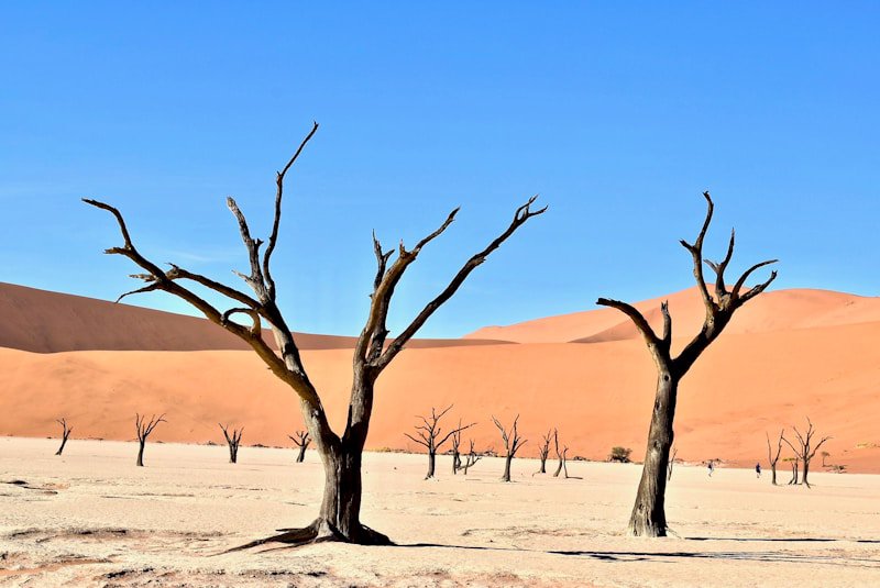
Leave early and treat the transfer as a full driving day. Stay near Sesriem for two nights so that one morning can be devoted to the dunes and Deadvlei. The final approach beyond the two-wheel-drive parking area is deep sand; use the shuttle unless both the rental contract and your experience support sand driving.
Park only in designated areas, carry water on foot and turn back before the heat becomes a problem. Gate times and access rules change seasonally, so confirm them locally.
Day 4 — Sesriem to Swakopmund (about 340–370 km)
This is another long gravel day. Refuel when practical, pause at Solitaire and keep speed conservative even when the road looks smooth. Corrugations can unsettle a vehicle quickly. Reach Swakopmund before dark and use the town to restock, check tyre pressures and arrange any guided coastal activity.
Day 5 — Swakopmund and the Atlantic coast
Keep the car parked for part of the day. Walk the historic centre, explore the waterfront or choose one reputable guided activity. Fog is common and makes dawn or evening driving harder. If visiting Cape Cross, check current opening times and add enough daylight for the return.


Day 6 — Swakopmund to Damaraland (about 320–450 km)
Choose either a shorter inland stop around Spitzkoppe or a longer push toward southern Damaraland; do not attempt both as rushed photo stops. Community conservancies and guided visits add context while directing income locally. Never follow an unverified track merely because it appears on a phone map.

Days 7–8 — Damaraland to Etosha National Park (about 300–400 km)
Enter Etosha with fuel, drinking water and a confirmed bed or campsite. Spend two nights in or near the park and divide wildlife viewing into early morning and late afternoon sessions. Obey speed limits, remain in the vehicle except at designated places and never crowd animals at waterholes.

Day 9 — Etosha to the Okonjima/Otjiwarongo area (about 250–350 km)
Drive south after a final morning wildlife loop. This intermediate night avoids an exhausting same-day return to Windhoek and creates a buffer for a puncture or slow road conditions. Book conservation activities directly with a credible operator and verify what is included.
Day 10 — Return to Windhoek (about 220–270 km)
Allow several hours for fuel, cleaning expectations and the rental inspection. Do not pair a long rural drive with an inflexible international departure. If the flight is early, return to Windhoek the previous afternoon.
Realistic planning budget
The following bands are for planning, not live quotes. Peak-season lodges and scarce automatic 4x4s can cost more.
| Item | Per person, 10 days (two sharing) |
|---|---|
| Vehicle, fuel and rental extras | US$650–1,100 |
| Camping or mid-range accommodation | US$550–1,250 |
| Food and water | US$250–450 |
| Park fees and activities | US$200–300 |
| Contingency | US$150–250 |
| Estimated total | US$1,800–3,200 |
Compare insurance exclusions, glass and tyre cover, excess, mileage, second-driver fees and cross-border rules—not only the headline daily rate. Reserve Etosha and Sesriem accommodation well ahead for July–October.
Road and vehicle essentials
- Drive on the left and avoid driving after dark; animals and unlit hazards are common.
- A high-clearance vehicle is the practical default. A 4x4 adds confidence on rough access roads but does not make unsafe speed acceptable.
- Ask the rental company for its approved gravel-road tyre pressure and maximum speed guidance.
- Carry at least one usable spare tyre; two are preferable on remote itineraries.
- Refuel before the gauge becomes low and never assume the next small settlement has working fuel pumps.
- Keep several litres of drinking water per person and tell accommodation staff your next destination.
- Download emergency numbers and rental assistance details before leaving Windhoek.
Accommodation strategy
- Windhoek (1 night): recover, collect the vehicle and shop in daylight.
- Sesriem area (2 nights): protects the Sossusvlei sunrise plan from a late arrival.
- Swakopmund (2 nights): rest, laundry, supplies and a weather-flexible coastal day.
- Damaraland (1 night): breaks the coast-to-Etosha transfer.
- Etosha (2 nights): enough time for more than one wildlife window.
- Otjiwarongo/Okonjima area (1 night): sensible buffer before Windhoek.
Local etiquette and low-impact travel
Ask before photographing people, support community-run conservancies and do not remove stones, plants or cultural objects. Stay on authorised roads, keep noise low at waterholes and pack out rubbish. Namibia is sparsely populated, not empty: farms, conservancies and communities have access rules that visitors must respect.
Entry and health preparation
Visa and entry rules depend on passport and can change. Verify them with Namibia's official immigration or diplomatic sources before booking. Check current health advice with a qualified travel clinic, ensure insurance covers remote-area evacuation and carry prescription medicine in original packaging.
Verification sources and editorial note
The route, seasonality and safety advice were cross-checked against official destination and park resources plus recent independent traveller discussions. Dynamic prices are shown only as broad planning bands. Reconfirm park fees, gate times, road conditions, fuel availability and entry requirements immediately before travel:
- Namibia Tourism Board: https://visitnamibia.com.na/
- Namibia Ministry of Environment, Forestry and Tourism: https://www.meft.gov.na/
- Namibia Airports Company: https://www.airports.com.na/
- Recent traveller discussions: https://www.reddit.com/r/Namibia/ and https://www.reddit.com/r/travel/
Why a rental car improves this trip
A suitable rental vehicle turns a collection of distant highlights into one coherent route. It gives you control over wildlife-viewing hours, lets you carry water and emergency equipment, and makes small conservancies and remote accommodation practical. The benefit comes from flexibility, not speed: build short days, daylight buffers and recovery time into the plan.



Travel Tips
No tips yet. Be the first to share!